-המעיין-רחפן-aspect-ratio-x

The Spring Trail(Blue)

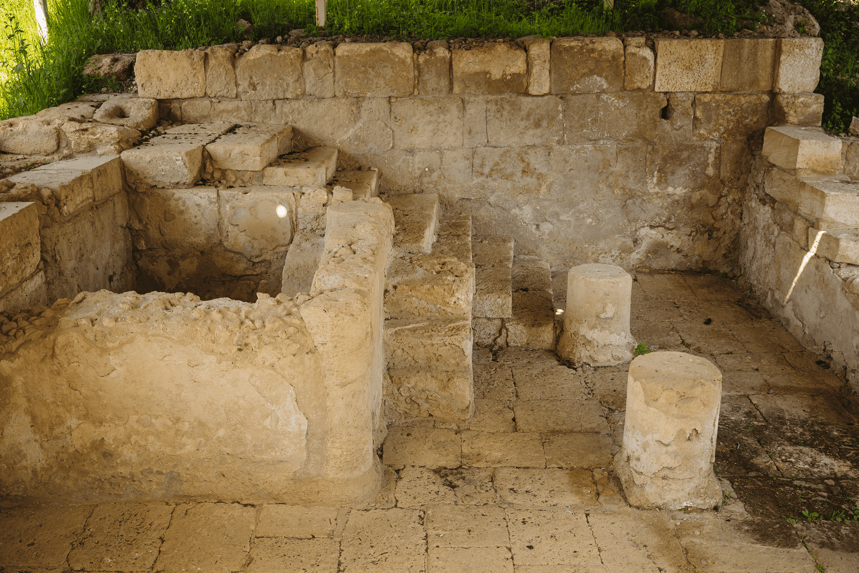
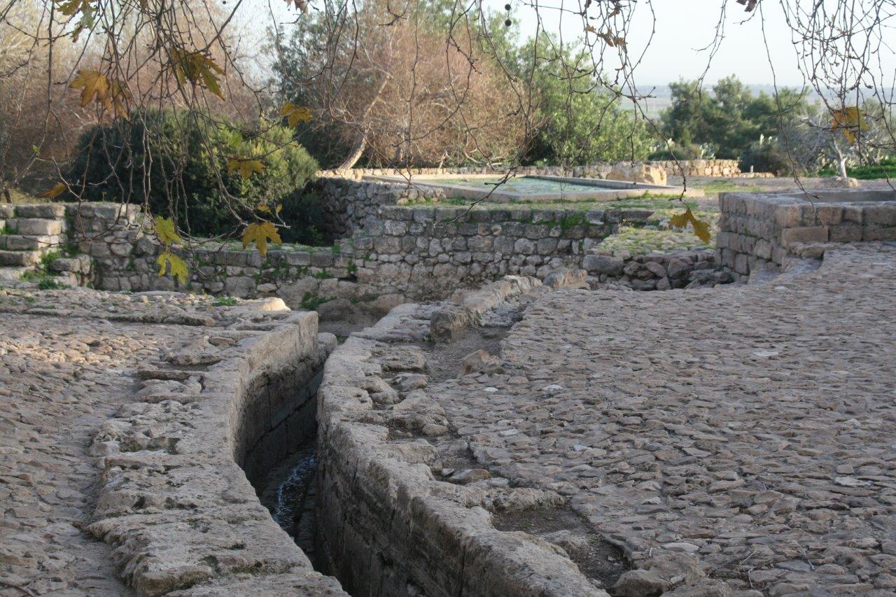
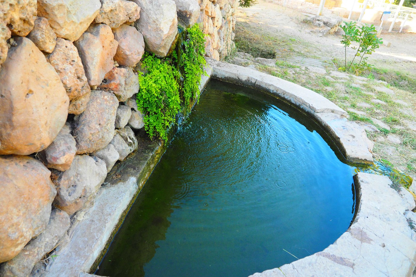
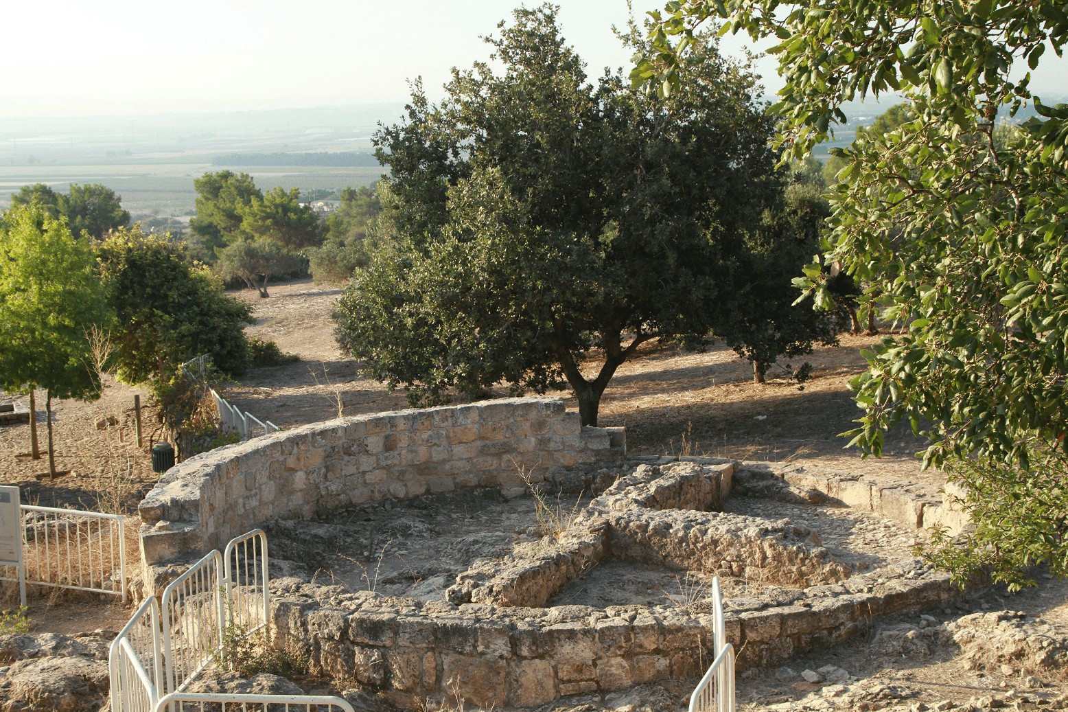
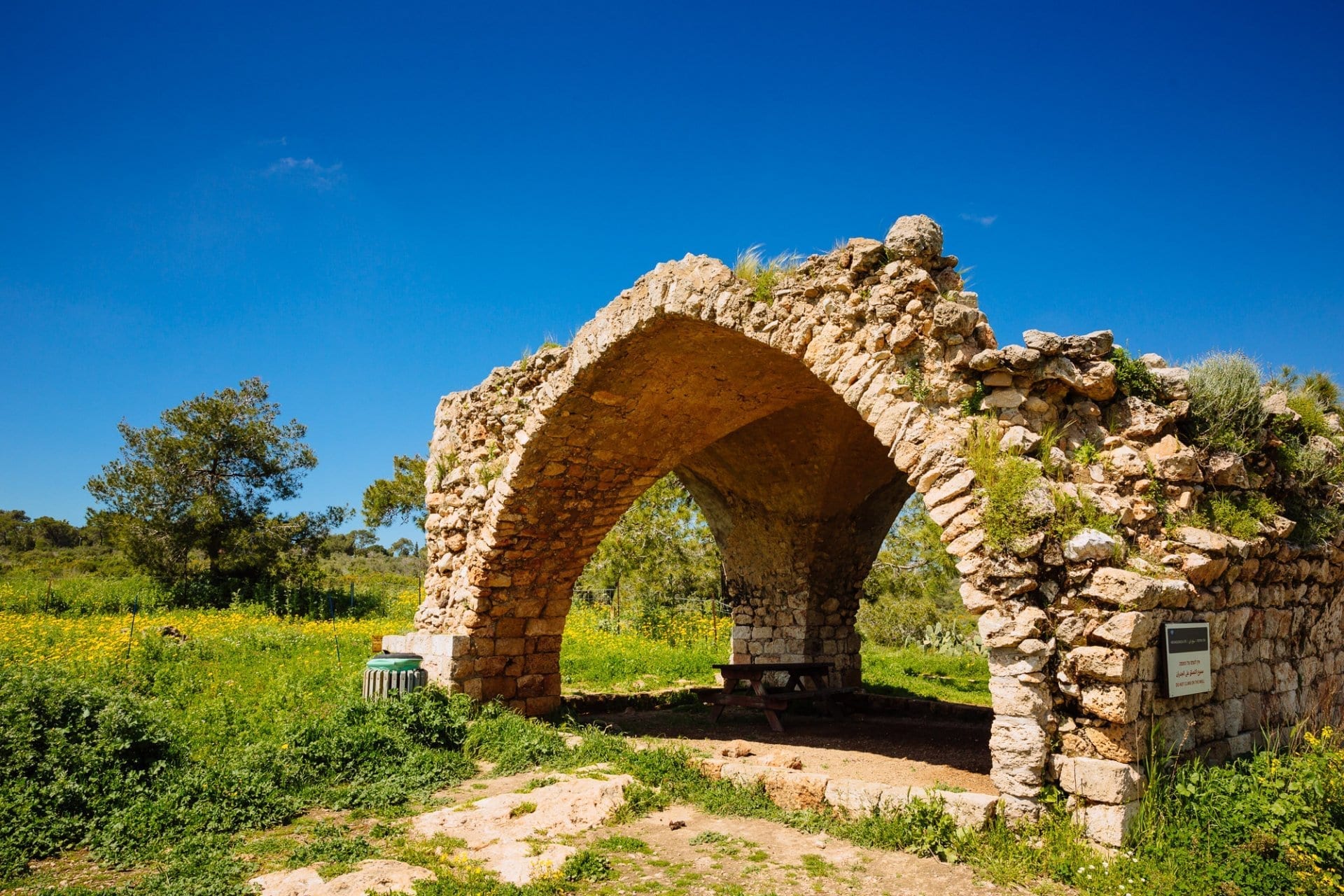
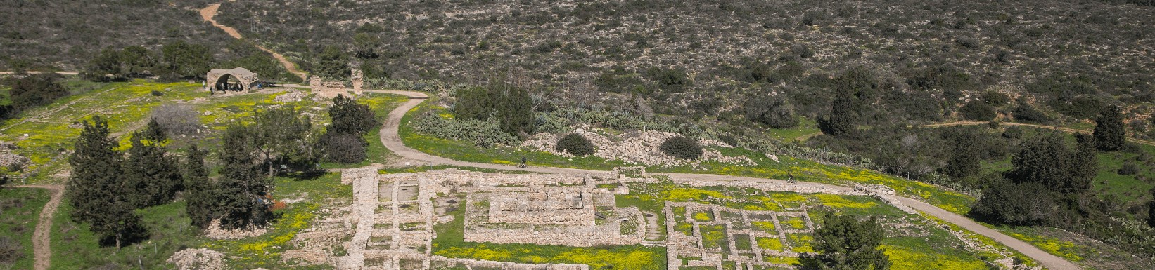
The route marked in blue is the Spring Trail, inviting hikers to a journey back in time: to a 2000-year-old agricultural settlement, a hidden spring, and a wishing well. The path passes Beit Houri, a farm dating from the Ottoman period. From there it continues to a Herodian palace, a remnant of the fortified farmhouse from the days of King Herod, and to Ein Zur, a spring and aqueduct used for ceremonial purposes during the Byzantine era.

Please note: due to massive construction near Kramim School, the entrance to Ein Zur spring has moved south (around the boat)

Ramat Hanadiv Nature Park, Israel.

Points of interest: Ein Tzur, a spring that flows year round through a tunnel that was hewn in the rock; a shaded brook; observation points overlooking vistas of Hanadiv Valley and the hills of Samaria; prehistoric agricultural areas (reconstructed); an ancient bath house; a rich archaeological complex; and the remains of a farmhouse from the Ottoman period.
Level: Suitable for families
Colour of markers: Blue
Download the Spring trail map
Click here for the navigation app WishTrip
Length: Approximately 2.5 kilometers
Hiking time: Approximately 1.5 hours
Departure point: The trail is circular, starting at the trailhead
Recommended seasons:  All year

Emergency telephone for on-duty supervisor (after closing time): 053-6452336

The Trail
From the trailhead, the trail marked in blue turns slightly left towards the southeast, crosses a dirt road, and enters a low scrubland  The trail again crosses a dirt road, then proceeds eastward to higher shrubland composed primarily of native plants – phillyrea  and mastic shrubs.Emerging from the thickets, the trail pauses at a stunning panorama of Hanadiv Valley and the Samarian hills (Station #1).

Download the Spring trail map

שביל המעיין - אלון

1.  Observation Point
Spread out below is Hanadiv Valley, cultivated primarily with vineyards and orchards. Immediately south of it lies the moshava (village) of Binyamina. North of Samaria, on the horizon beyond the valley, one can see Mt. Amir, where the towns and villages Umm el-Fahem, Mei Ami, Katzir and Arara are located. To the north are the houses of Zikhron Ya’akov.
The trail continues to a stone step, where a large carob tree is growing
(Station #2).

2. Large Carob Tree
The stone step here indicates the existence of a geological rift line. Beneath the step the top layer of hard limestone has been worn away, exposing the volcanic stone beneath it. The leafy carob tree provides a welcome resting spot for hikers.The trail slopes off to the right, then immediately turns left into a grove of cypresses.

Beyond the fence to the left is a Moslem cemetery that belongs to the old village of Umm el-‘Aleq. The trail continues towards the left and crosses a dirt road. It passes a thorny hedge of ‘Sabra’ cactus (Opuntia ficus-indica) bordering the ‘Aleq ruins, and the remains of an oil press, located in the shade of the carob tree (to the left), before reaching a large Tabor oak
(Station #3).

שביל המעיין - בריכה אקולוגית

3.  Tabor Oak
The Tabor oak(Quercus ithaburensis) is a deciduous native tree that grows abundantly from the Sharon plain to Ramot Menashe, the Galilee and the Golan Heights. Its large acorns are an important source of food for Eurasian jays, rodents, and wild boars. The trail goes down past the area of the spring (to which we shall return), descends into a grove of willow trees, then continues towards the brook.
A wooden footbridge crosses the water, and the trail ‒  now a paved stone path ‒ goes down further to a little wetland
(Station #4).

4.  Wetland
An experiment aimed at recreating a wetland is being conducted in the pond and its surroundings.   Dense clumps of water parsley (Apium nodiflorum), a relative of cultivated celery, are growing here among the other aquatic plants.
In the past Israel had many wetlands, breeding grounds for amphibians such as

common tree frogs (Hyla savignyi), marsh frogs (Rana  ridibunda), and  green toads (Bufo viridis). With the draining of the swamps, exploitation of water sources, and consequent destruction of most of the seasonal ponds in the country, such habitats became rare. The pond here, created to facilitate and encourage the proliferation of plants and animals native to wetlands, also serves as an important on-site laboratory for Ramat Hanadiv’s Education Department.

From here, there are three options: 

• A right turn brings walkers to the parking lot of the ORT School.

• A left turn leads hikers up to the trail marked in yellow, culminating at the historic Tel Tzur hill. (It takes about 10 minutes to get to either destination.)

• For those who want to continue walking: The Spring Trail continues straight on, passing an olive grove (on the right) and a Geiger tree  notable for its wide leaves (on the left). At the beginning of the 20th century, tests were conducted to see whether this tree could be cultivated for use in the glue industry. Next to it is a hedge of sweet acacia trees  which were studied too, for possible commercial use in perfume. The trail returns from here to the grove of willow trees and then ascends metal steps to the bath house (Station #5).

שביל המעיין - בית מרחץ
5.  Bath House
In front of us is the bath house dating from the Roman period. Its water supply came from the adjacent Ein Tzur spring, enabling the residents of the Horvat ‘Aleq site to bathe in hot water. The structure is divided into four long, consecutive rooms.  From the entrance, bathers walked down seven steps to the dressing room (apoditerium). After immersing themselves in cold water, they entered the warm room (tepiderium), then moved on to the hot bath or sauna (caldarium). Note the many short columns here: they raised the floor level so that the warm air generated by the heating installation next door could circulate into the space beneath the floor and heat the room.
The trail passes the bath house en route to the water system of Ein Tzur, which includes the spring, reservoir, tunnel, and a constructed pool (Station #6).
שביל המעיין - הנקבה מבפנים

6.  Ein Tzur and the Water System
In the Ein Tzur tunnel three shafts, 11 metres apart, were hewn out of the bedrock in order to illuminate and ventilate the dark tunnel and to facilitate maintenance of the water system. The tunnel takes a winding, 47-metre long route along a natural fissure in the bedrock, the source of the water. In the winter of 2001, a f
lood damaged the tunnel’s roof. A pillar was erected at the entrance to the tunnel in order to reinforce the roof; it was based on the example of an ancient pillar next to the first shaft.
During the Roman period water accumulated in the tunnel, possibly for use as aritual bath.
Tal glick

To raise the water level and create a pool within, the opening of the tunnel was blocked.Some 2,100 coins from the Byzantine period (324-638 CE) were discovered beneath this tunnel. A historic source from that period (the ‘Bordeaux Pilgrim’) attributes healing powers to a spring at Har Sinah, near Caesarea. It is likely that this was the pool that attracted pilgrims in those days: women apparently came to bathe here, hoping to enhance their fertility, and dropped the coins into it.

The large reservoir at the end of the aqueduct supplied water to the bath house and fields as well as serving as the bathing pool. When Beit Khouri was established above the archaeological site (approximately 1880), the Ein Tzur reservoir was moved to a new pool built of stone, west of the Roman pool, and its water was pumped up the hill to the farmhouse.

In 1939, a group of young Jews from the Betar youth movement founded a small ‘stockade and tower’ settlement on the hilltop east of the spring, which they named Tel Tzur Hahadasha (the New Tel Tzur). Near the Roman pool they built an additional one of concrete, which provided the settlement’s water needs. As mentioned above, one can visit the historic Tel Tzur site on the trail marked in yellow, which exits from the area of the brook.

From the aqueduct, the trail goes up the stairs beyond the dovecote (Station #7).

שביל המעיין- בריכה1
7.  Columbarium (Dovecote)
Doves served a multitude of purposes in ancient times: their eggs and meat provided food; their excrement was a valuable fertilizer; and they performed ceremonial roles in both pagan and Jewish rituals. The columbarium here was built as a round tower that reached a height of 18 metres. Its name reveals its function: the Latin word columba means ‘dove’. As one can see from the reconstruction of the structure, the birds entered the tower through apertures in its upper section and nested in small cubbyholes built for them inside, within the walls of the tower and in two additional, interior walls placed side by side. The tower’s outer walls were covered by heavy layers of smooth white plaster. The columbarium workers entered the tower on a ladder via a raised opening at the side of the tower.
The plaster and the raised opening prevented reptiles and other animals of prey from scaling the walls and getting into the columbarium.
The trail turns left and continues west to a large archaeological complex (Station #8).
קולומבריום
8. Horvat ‘Aleq Archaeological Complex 
Archaeologists have discovered numerous treasures here. Strategically located next to a source of water in a fertile agricultural region, this multi-layered site was already populated by humans in the prehistoric period, more than 10,000 years ago. The settlement continued to be inhabited until the 2nd century CE, through the Iron Age and the Persian, Hellenistic and Roman periods. The site has been reconstructed as it was when it reached its acme in the early Hellenistic period. The remains of the original stockades and towers that surrounded it then are clearly evident in the area. Settlement was renewed towards the end of the Ottoman era with the establishment of the village of Umm el-‘Aleq.  Archaeological findings bear witness to the extended, ongoing habitation of this place and to the residents’ long lives during the different periods of settlement.

The trail turns left and passes next to Beit Khouri (Station #9). A visit to the site is recommended.
In front of Beit Khouri, the trail turns left and enters a sparse pine grove (with an understory of mastic trees . It passes a Tabor oak , runs into a dirt road, and turns left onto it. After some 20 metres, the trail turns right up the slope and then traverses several ancient quarries (Station #10)

Ramat Hanadiv Nature Park, Israel.

9.  Beit Khouri
This structure is the remnant of a large farmhouse built by the El-Khouri family around 1880. It was constructed, room by room, around an internal courtyard. Most of the building stones were taken from the ancient  farmhouse at Horvat ‘Aqav. Though the El-Khouris themselves were Christian, they built a mosque for their Moslem tenants, the large hall that stands out at the south side of the manor house.
In 1913, the Jewish Colonisation Association (ICA) purchased the El-Khouri farm on behalf of Baron Edmond de Rothschild. Today the farmhouse and lands surrounding it are part of the grounds of Ramat Hanadiv.
From 1919-23, three groups of Jewish pioneers settled here. Due to the difficult conditions, however, their settlement experiments did not succeed.

Remains found at the manor house document the lives of the pioneers: the floor (cast in 1920) of the mosque hall, which served them as a dining room, and the charred brick oven which can still be seen in the kitchen.

10. Ancient Quarries
Within Ramat Hanadiv’s perimeters are many limestone quarries; they supplied building stones for the ancient settlements here and perhaps those nearby. The limestone layer that yielded the construction stones was no more than six metres deep.  When miners reached the soft bedrock beneath the limestone, they left their shallow quarries behind and went elsewhere to mine. Over time, most of the quarries were buried in soil and vegetation; others turned into seasonal pools in rainy winters and served as habitats for frogs, toads, and other aquatic creatures.
From here the trail returns to its starting point at the trailhead.


Enter the WishTrip app – WAZE for hikers – and use it to plan your visit. The app will also guide you through your visit, informing you about points of interest along the trail. You can get an impression of the place from the existing photos and videos, and/or upload some of your own.


Thank you for choosing to hike in the Nature Park at Ramat Hanadiv. We’ve put together a number of tips and guidelines for you so that your hiking experience will be safe and enjoyable: 
Hiking Correctly

אולי יעניין אותך גם...

Accessibility

Accessible Trails

We have worked hard to make our buildings, infrastructure and service accessible to special sectors of the population so that everyone can enjoy an accessible and enjoyable visit to the Memorial Gardens and Nature Park.

For further information >>

נגישות בשטח

Physically Disabled in the Gardens

Many trails traverse the Memorial Gardens. We recommend this route, but you
can choose to walk another route.

For further information >>

Dining Here

Dining-The Picnic Site

The picnic area is located near the secondary parking lot. You are welcome to spend time there before or after your tour of the Gardens.

For further information >>
09Yadid_Levy_Nadiv_May18_1117-scaled-aspect-ratio-x

Physically Disabled in the Gardens

Many trails traverse the Memorial Gardens. We recommend this route, but you
can choose to walk another route. Nevertheless, we recommend you print out the
full route before you set out on your walk, in order to avoid a frustrating
encounter with stairs at several places along the way. For your convenience,
wheelchairs may be borrowed from the InfoShop.

180720120276
Description of the route:
The tour begins at the entrance gate, overseen by the Rothschild family
Inside the gate, the entrance area is paved and divided into five long strips, representing the five Rothschild brothers. The number five repeats itself as a motif throughout the Gardens. . To the right of the entrance area is a shaded spot with benches, providing a convenient and pleasant meeting place

Fragrance Garden

The path continues straight ahead and leads to the Fragrance Garden, which was designed especially with visually impaired visitors in mind. It is intended to appeal to the senses of smell, touch, and sound, as well as to the sense of sight. The garden contains raised beds of fragrant and sweet-smelling plants, flowers, and herbs. A guide rail above the retaining wall of the raised area is studded with explanatory labels in Braille, in addition to signs in Latin,

Hebrew, and Arabic. A wooden pergola with benches provides shade and a place to sit and enjoy the soothing sounds of the fountain.

לקויי ראייה עם כלב נחייה בגן הוורדים

Palm Garden

Continue along the path to the Palm Garden, which contains a small sample of the more than 2,800 varieties of palms from all over the world. Among the types of palm cultivated here are those with tall, straight trunks and tousled boughs; round, crested sprouts that grow close to the ground; and fountain-like splayed foliage. Most familiar of these is the Washingtonia, long known as a trademark of the Baron’s settlements.Samaria Observation Point

Further along the trail is the Samaria Observation Point, which opens onto a view of the Samarian hills, and the Rose Garden.Rose Garden

This garden contains one large and five small pools with fountains, representing Mayer Amschel Rothschild and his five sons, while the roses themselves, in their variety and profusion of colour, recall the love that the Baron and Baroness had for flowers. New varieties of roses for gardening and landscape are constantly being tested in the nurseries of Ramat Hanadiv.

At the far end of the garden is a semicircular stone pergola rising behind the sculpture of a crouched woman holding a sundial. The woman looks away from the dial, as if divorced from time, hinting that here, time stands still.

The Crypt
The path crosses the Rose Garden and continues on ahead. Turn left at the intersection of the paths towards the Crypt. A second turn to the left is indicated by a sign leading to the courtyard of the Crypt. The paved courtyard is surrounded by a decorative pool and a colonnade of black marble pillars. A large cypress tree, reminiscent of a flame, is the dominant feature of the courtyard, representing a memorial candle. To the right of the tree is a sculpted stone ‘cup of tears’ that drips water into the channel below.

Pass through the heavy metal gate to a low passageway that leads directly to the Crypt itself. The entrance is illuminated by rays of light that pierce the stone exterior. Overhead, six heart-shaped lamps light the passageway. Two strips of black stones in the paved floor represent the inevitable descent to death.

In the burial Crypt is a tomb of black polished basalt in the form of a seven-sided polygon. It is here that the Baron and Baroness were reinterred twenty years after their deaths. Their son, James de Rothschild, fulfilled his father’s wish to be laid to eternal rest ‘in the rock’ of Israel, close to the community of Zikhron Ya’acov.

מבוגרת עם קביים בגן

Cascade Garden
Return to the main path and turn right. The curved path leads to the Cascade Garden, which acts as a window to the western landscape of the Mediterranean Sea below.

A stone relief map at the top of the steps indicates the location of forty-four settlements established or supported by the Baron. The names of several settlements recall members of the Rothschild family: Binyamina for the Baron himself, Binyamin; Zikhron Ya’acov, in memory of his father, Jacob; Meir Shefeya, in memory of his paternal grandfather, Mayer Amschel, founder of the Rothschild dynasty, together with the original Arabic name for the spot, Shafa (‘beautiful’); Bat Shlomo, in memory of his uncle and maternal grandfather, Solomon; Givat Ada, in memory of Baroness Adelaide; Pardes Hanna, in memory

of his Uncle Nathan’s daughter; Mazkeret Batya, in memory of his mother,

Betty; Ashdot Ya’acov, in honour of his son, James, who carried out his Will.

The Memorial Gardens were designed on the basis of contrast: between life and death, flowing water and stone paths, sun and shade. At the bottom of the Cascade Garden is a pool that features a sculpted pair of hands on its rim. The hands seem to be attempting to hold the water that streams forth, symbolizing the inability to stop time.

From the upper part of the garden, continue straight in the direction of the entrance gate. Seven broad steps lead back to the entrance area and the gate of the Memorial Gardens. Visitors in wheelchairs may circumvent the steps by turning left and taking a longer but level path back to the gate.


Of further interest...

Timeline

Ramat Hanadiv Timeline

Who lived at this spot 70,000 years ago? What major event took place in the gardens in 1954? And what's been going on at Ramat Hanadiv ever since then?
We invite you to find out by getting into a virtual time

For further information >>

Sustainability

Sustainable Gardening

Sustainable gardening is defined as gardening that considers the needs of the current generation without harming the needs of future generations. It includes garden design that considers the existing elements on site – the landscape, soil, environment and vegetation suitable for the region

For further information >>

Dining Here

Dining

To complete your Ramat Hanadiv experience, you are cordially invited to enjoy the culinary pleasures of Mata’im, the cafe-restaurant on our premises.

For further information >>
21586540_1482539138500091_7442276502927261688_o-aspect-ratio-x
תמונה ראשית
Mata'im Restaurant
Kiosk
The Picnic Site

To complete your Ramat Hanadiv experience, you are cordially invited to enjoy the culinary pleasures of Mata’im, the cafe-restaurant on our premises. With an accent on absolutely fresh ingredients and healthful eating, Mata’im offers a top-quality (kosher) dairy menu that brings diners to a new appreciation of the earth, of roots, and of the magnificent environment enveloping themselves and the restaurant.

Mata’im is also proud of its social agenda: Part its staff is comprised of youth at risk, who are being trained for work in the restaurant business — paving their way to fruitful careers and successful integration in society.

NitzanZohar-54

Mata’im – The Natural Place for Your Next Event

The restaurant is a relaxed and gracious venue for catered private celebrations and business events. Alongside Mata’im are meeting rooms and an auditorium equipped with the latest technology — the perfect site for seminars, staff meetings, training sessions, lectures and workshops.

Opening Hours:
Sun – Thurs: 8 a.m.-2 p.m. | Friday: 8:00 – 13:00 (On Fridays, openings hours may change. It is recommended to check before arriving).
See below opening hours during the holidays.

To reserve restaurant tables in advance (highly recommended) or plan an event, please ring us at:  04-8449998

For coordination and clarification regarding events only:

Business Events: Bell Ifraimov 053-469-8392
Private Events: Eran Peretz 053-611-0941

Diners at the restaurant pay only NIS 10 for parking.  To obtain the discount please ask the restaurant staff.