Science and Technology at Nature's Service

Climate change carries predictions for reduced amounts of water in the future, and we’re keeping our finger on the pulse. Using advanced technological methods, we’re studying the state of water in the soil and plants over time.

דנדרומטרים

What happens to water in the soil?

What happens in the soil after the rainwater infiltrates? How available is the water to the vegetation? How much of it will infiltrate and how much will evaporate? How will the vegetation in the park respond to changes in the amounts of water in the future?

To obtain answers to these questions, we set up a new station for monitoring the water balance in the soil. In the deep soil, to which the trees’ roots reach, we installed soil moisture sensors; they transmit the data to the computer through cables. The data are then transferred to researchers at the Weizmann Institute and the Volcani Center, who will analyse them over time, under the direction of Dr. Yagil Osem.

The data will help us improve our understanding and ability to predict the impacts of changes in rainfall patterns on the ecosystem at Ramat Hanadiv. By studying the water balance and the amount of water available to the plants, we’ll be able to manage and plan the vegetation at the park

accordingly: in the grazed area, for example, we’ll be able to maintain a maximal amount for the herbaceous vegetation and reduce the shrubs, while the designated picnic area requires shade from tall trees and soil free of shrubs.

The new station joins the meteorological station which was set up at the park in 2003; it measures the rain events and the climate conditions.

infra red
an example of infra-red photography in Hanadiv Stream: the redder the trees, the healthier they are, and the browner the trees, the drier they are.

Blushing before the camera

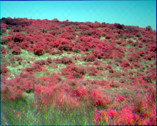
There are more than 2,000 trees at Ramat Hanadiv! The gardening staff looks after each and every one of them. To obtain a clear picture of their state of health, we use infra-red photographic technology once every few years: aerial photography using special sensors that can absorb a wavelength that the human eye is unable to see.

‘Infra-red photography provides an estimate of the state of chlorophyll in the tree,’ explains Lior Hershkovitz, the gardens’ curator. ‘Chlorophyll is a pigment found in plants, mostly in the leaves. It absorbs the light energy required for photosynthesis. The better the state of the chlorophyll, the better the state of the tree. The photographs provide information about each species of tree, allowing detection of deviations, and identify trees in a state of desiccation or thirst. After identifying the problematic trees, the gardening staff can treat them – by means of additional irrigation, identification of pests, etc.’

The gardens were mapped using infra-red technology for the first time in 2016; this month it will be mapped again to compare the state of the trees then and now. For example, we found a decrease in the vitality of certain trees such as the Callery pear, small-leaved fig, and date palm. The aim is to identify trends in trees and draw conclusions about their integration and treatment.

Did you like it? Join our free mailing list to receive monthly news and updates about activities for the whole family. Register here.